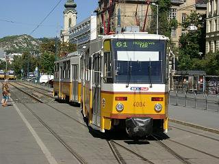
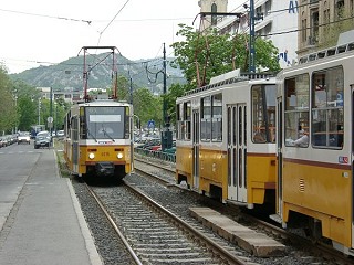
Route 61
Update, March 2016: The interconnected tram network in Buda was launched in January and completed in March 2016. Although there are smaller construction works still to be carried out, the tram network changed big time: routes 17, 19 and 41 are longer, there is a route 56 again after a few years of hiatus, while the line number 18 is gone, and there are new services (47B, 56A and 59B). I'll try to update every page affected by this, but it will take some time, and you might see photos and information from prior the changes for a while.
Route 61 used to be the outer tramway circle on the Buda side (with route 18 being the inner one) - a direct link between the two busiest urban transit interchange points on this side of the Danube: Móricz Zsigmond körtér and Széll Kálmán tér. Of course "direct" doesn't mean "straight": the line must go around Gellért-hegy (a large and rocky hill right by the Danube), and climb a saddle between smaller hills of the Buda mountains via two short but steep sections. In December 2008, tram 61 was merged with tram 56, so it's now "the" Buda mountain route, connecting Central-Buda with the noble hill areas around Hűvösvölgy.
The southern half: most parts here were built out in the 20th century, therefore the area didn't need a tram service until the late 1920's. Although the northern section between Széll Kálmán tér, Déli pályaudvar and Nagyenyed utca was built earlier, the rest was inaugurated as late as 1929 (Móricz Zsigmond körtér - Budaörsi út) and 1930 (Budaörsi út - Déli pályaudvar). The fact that it was built out so late, had some advantages: the tracks in Villányi út (then called Szent Imre herceg útja) were already laid on reservation with Vignoles rails from the start. The stretch in Alkotás utca was widened and modernised in the 1970's, since then the whole Széll Kálmán tér - Móricz Zsigmond körtér section has a bit of LRT appeal, although it's still operated as a tram (e.g. still way too many unsecured level crossings with vehicular traffic).
The other half of the line - known as tram 56 until 2008 - is one of the more prominent ones of the Budapest tram network. It runs in wealthier areas of Buda, and is relatively well maintained - at least in contrast to some other services of Budapest. Some historic features (like the old wooden booths in the stops) and the surroundings make the route a must. As for patronage: on working days the line's most important job is to carry people from the mountain suburbs into the inner city of Buda, while on weekends it turns into an excursion service: Hűvösvölgy is a popular picnick-place with forests, restaurants and of course the Children's Railway, a.k.a. the Pioneer Railway.
Hint: For railway enthusiasts it's highly recommended to make a round-trip like this: go up to Hűvösvölgy with tram 61, travel to Széchenyi-hegy with the Children's Railway, and then to come down to the city with the Rack Railway.
![]()
Route 61: Móricz Zsigmond körtér - Villányi út - Alkotás utca - Krisztina körút - Széll Kálmán tér - Szilágyi Erzsébet fasor - Hűvösvölgyi út - Versec sor - Alsó Völgy utca - Hűvösvölgyi út - Hűvösvölgy (11 km)
Vehicles: 25 x T5C5K double-set (from remise Szépilona)
![]()
The route starts in a side-street of Móricz Zsigmond körtér, with a recently-built-but-rarely-used connection to the tram lines in Fehérvári út.


The terminus at Móricz
Zsigmond körtér with the rocks of Sas-hegy in the background
-> More about route 61's terminus at Móricz Zsigmond körtér
As I already mentioned, the tracks in Villányi út run on reservation within a green strip in the middle of the street. There are however many small streets crossing the tracks, so it's definately not a Stadtbahn :-) Architectually the higlight is around Tass vezér útja, where on one side of the street you can see a richly decorated parochial high school with a church (seen above on the left-hand side), and on the other side a small park with a lake in it.
Further to north mansions dissapear and give place for some nice old (and also some ugly newly-restored) villas.
The "garden suburb feeling" ends when the tram reaches the junction of Budaörsi út, Alkotás utca and Hegyalja út, commonly known as "the BAH junction" (BAH-csomópont):
This is where most of the traffic of the
motorways from Vienna and Lake Balaton "crashes" into the inner
city of Buda, making the place a bit of a mess. Attractions nearby:
-the nature reservation area on top of
Sas-hegy
(a rocky hill with some rare botanical features)
-the park "Gesztenyéskert" located
around the Budapest Congress Center
Alkotás utca starts with a strong slope with some modern buildings on the top.
I think this climber is quite photogenic, especially with that strange building in the background, which looks like a large sail-boot.
To the left: the slope from the other way around, with the flyover bridge leading towards the highway to Vienna. To the right: the stop at Csörsz utca is dominated by the large building of a mall.
Now we're on a plateau, where one side of the street reflects the early-to-mid 20th century with mansions, while the other is just being built in with some modern office blocks. Here trams are not easily photographable because of strong vehicular traffic.
The plateau ends in another slope...
... which is the steepest one in the city. Okay, it's still nothing compared to Gmunden or Stuttgart or San Francisco - and in contrast to route 59 (which runs like that upwards for more than a kilometer) there's a fair chance that you wouldn't even recognise it beeing steep, but hey, that's what we can offer you concerning gradients :)
The rest is pretty relaxed until...
... the line reaches Nagyenyed utca, where it joins route 59. In the background you can make out the Postal Palace at Széll Kálmán tér, and on the right-hand-side you'll find Déli pályaudvar (Budapest South railway station), where a couple of trains from Vienna arrive to.
After the stop of route 59 and 61 these services are joined by route 18.
->
Continue to Hűvösvölgy via Széll Kálmán tér
->
Continue on route 18 heading for Döbrentei tér
![]()
Back to the
top
Back
to the opening page
Back
to the clickable map
Disclaimer: The author cannot
be held responsible for mistakes, misinterpretations, inaccuracies, inactualities,
etc. on/of these pages, nor for the content of other pages linked in.
![]()
Send
a mail to the author
The
author's homepage