Tram-hiker's
guide to Budapest
Latest update: 5. February,
2017
![]()
Closing time, February 2017: Since I don't have the time to work on this website, I won't be updating it anymore.
The map seem to be broken with some web browsers :( Any help in this is welcome, as I don't have time to redraw all clickable parts of the imagemap.

Thanks to Mr. Ádám Kovács for
the original map!
Legend:
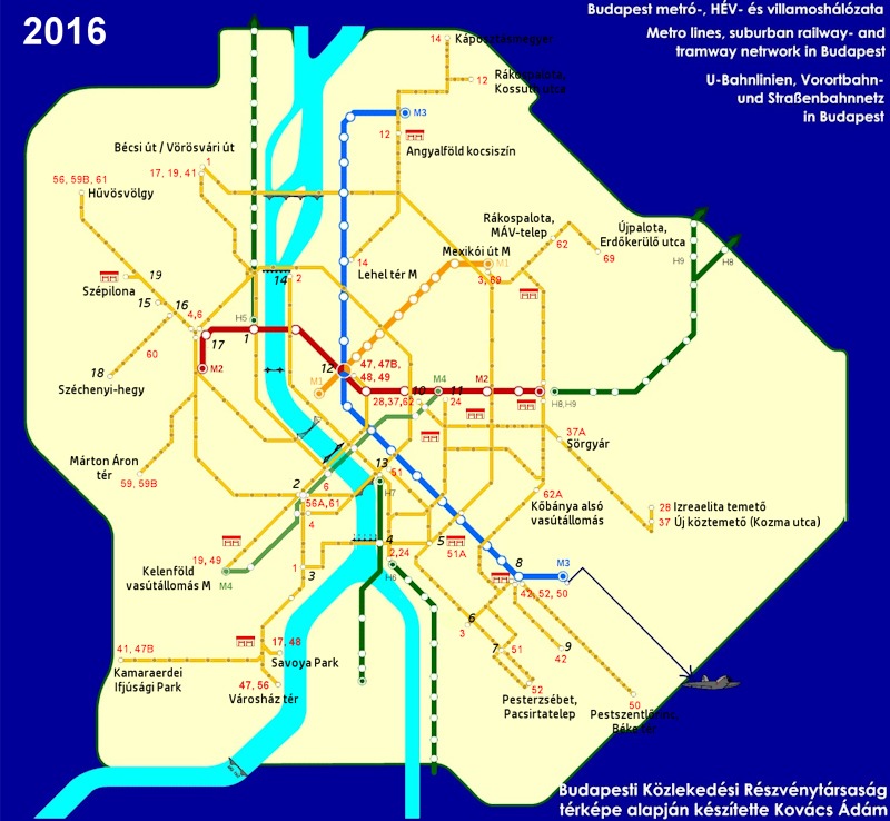
The orange-ish lines are tram routes (with dots as stops; only the termini are written out with respecting route numbers). Green lines show the HÉV (suburban) railway lines. The four subway (metro) lines are shown with yellow (M1), red (M2), blue (M3) and light green (M4). Suburban railways operated by the BKV (HÉV lines) are dark green. The small house icons represent depots ("remises" as we say). Black "X"s mark temporarily closed stretches, while blue "C"s are newly sections currently being built.
Red-ish/orange-ish numbers are line numbers, while black, slanted (italic) numbers are for termini that did not fit onto the given space:
| 1 - Batthány tér | 11 - Keleti pályaudvar M |
| 2 - Móricz Zsigmond körtér | 12 - Deák Ferenc tér |
| 3 - Fehérvári út / Hengermalom út | 13 - Mester utca / Ferenc körút |
| 4 - Közvágóhíd | 14 - Jászai Mari tér |
| 5 - Ferencváros vasútállomás | 15 - Szent János kórház |
| 6 - Gubacsi út / Határ út | 16 - Városmajor |
| 7 - Nagysándor József utca | 17 - Széll Kálmán tér |
| 8 - Határ út M | 18 - Széchenyi-hegy |
| 9 - Kispest, Tulipán utca | 19 - Budagyöngye |
| 10 - Blaha Lujza tér M | 20 - Clark Ádám tér |
If you're looking for a map also showing streets and other objects, here's one on the BKK website!
Disclaimer: The author cannot
be held responsible for mistakes, misinterpretations, inaccuracies, inactualities,
etc. on these pages, nor for the content of other pages linked in.
Map courtessy of Ádám Kovács
![]()
Send
a mail to the author
The
author's homepage