Update, March 2016: The interconnected tram network in Buda was launched in January and completed in March 2016. Although there are smaller construction works still to be carried out, the tram network changed big time: routes 17, 19 and 41 are longer, there is a route 56 again after a few years of hiatus, while the line number 18 is gone, and there are new services (47B, 56A and 59B). I'll try to update every page affected by this, but it will take some time, and you might see photos and information from prior the changes for a while.
The surroundings of Móricz Zsigmond körtér ("körtér" = circus) - now one of the busiest nodes in the transit network - were a dull place with the road to Székesfehérvár leading through it until the end of the 19th century. First, BKVT's electric tram to Kelenföldi pályaudvar (Kelenföld station) arrived in 1898 via Bartók Béla út, then the BBVV vicinal between Szent Gellért tér and Budafok diverged from those tracks here by turning onto what's now called Fehérvári út (In fact, back then the piece of today's Bartók Béla út between the Danube and this place was also called Fehérvári út).
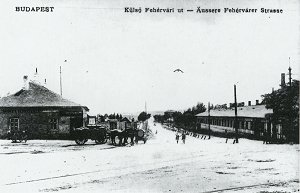
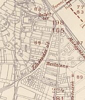
To the left: looking southwards
in Fehérvári út around 1900. The the right: a map from the early
1910's.
It was no big junction, just the tram and vicinal tracks parting ways. There weren't even houses around here in those days!
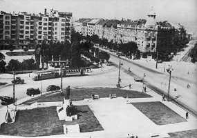
The reversing loop around
the
statue in 1940. Note that the other half of the square (in the background
with the trees) is yet untouched by trams.
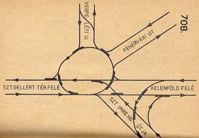
Around 1912 they've built a reversing loop around the middle of the square, where the statue of Prince St. Emericus was placed. This loop also functioned as a roundabout for all tram and vicinal routes (the Budafok service was extended to Tétény, and it also received a new branch to Törökbálint) going through here. In 1929-30 today's route 61 was built in Villányi út, (known as "Szt. Imre herceg útja" ("Street of Prince St. Emericus") on the map above) and in 1937 the Grand Boulevard routes arrived via Petőfi híd and Karinthy Frigyes út. ("Verpeléti utca" on the map)
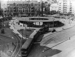
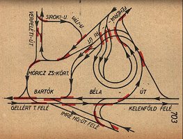
To the left: vicinal train
arriving via Fehérvári út to the loop around the terminal. To the
right: the quite impressive track layout from 1952.
Between 1940 and 42 the square was reorganised as the Southern-Buda "counterpart" of Széll Kálmán tér. A new, multi-track reversing loop was built on the unused half of the square, with a terminal building (nick-named "the mushroom") in the middle of it. This was the new inner end point of the vicinal services to Budafok, Tétény and Törökbálint. In 1963 these vicinal services were converted to tram routes 47, 43 and 41, but the track layout remained, with only a few minor alterations over the years. Of course these alterations consisted mostly of removing tracks - one after another.
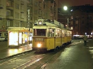
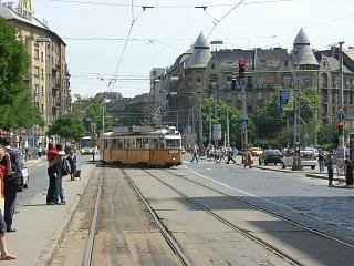
To the left: UV double-set
of route 41 in the reversing loop around "the mushroom".
To the right: UV triple-set
of route 47 turning leaving Bartók Béla út towards Fehérvári
út.
The reversing loop around the ex-vicinal terminal building was rarely used after 1972, but then it was taken in use again in 1993 by route 41. By the year 2000 most service connection tracks were gone from the square, and the remaining rails were in a sad condition.
The square was rebuilt in 2002-2003 in accord with Bartók Béla út and Fehérvári út. The reversing functions of the multi-track loop around "the mushroom" are gone since then, and no connections were built to route 6 because of the short-sighted scrimpyness of the city.
![]()
The transportation highlights of Móricz Zsigmond körtér are
The terminus of route
6
The terminus of
route 61 with connection to Fehérvári út
Route 19 and 49
Route 18, 41
and 47
The
reserve terminus in Fehérvári út
Remark: Much of the square is occupied by the metro construction site nowadays, and the rest is also quite "under construcion". It's been like that since 2002, and I find this really annoying :(
![]()
On 19. May 2006 the reversing loop of route 6 at Móricz Zsigmond körtér was abandoned.
A new, two-track stub one was built instead, which is now used by the Combinos.
Interestingly the two tracks are indented into the middle of the street, because the authorities did not wanted to allow a terminus laying in a slope. I call the resulting hole "the snakepit", for obvious reasons (just look at those trams winding in and out!).
-> Link to route 6's section in Karinthy Frigyes út
![]()
The terminus of route 61 is located on the opposite side of the square, in Villányi út, which also acts as the reversing point of a variety of buses.
A brand new connection between Villányi út and Fehérvári út (left) was built in 2008, and although it was officially taken over by the BKV in 2009, it's not used by any revenue services yet. The only trams I ever saw on these tracks were the technical acceptance test vehicles and some charters (like the one on the right-hand-side)...
Hint: The bus service 27
starts from here to the top of Gellért-hegy (St. Gellert's Hill).
Hint: The characteristic
catholic high school next to the terminus is also a nice photo-object.
Hint: A few hundred meters
away you'll find a small park with a nice lake in it opposite to a neo-baroque
church. This is a nice place for a few minutes of rest.
![]()
Bartók Béla út has lost its traditional appeal of being a UV trunk line on 21. August 2007. Now you will almost only see Ganz articulated cars in this stop (left). Of course with some luck you can also see special transports coming from or going to Remise Kelenföld (right)...
![]()
Tram routes 18, 41 and 47 take a sharp turn south, from Bartók Béla út into Fehérvári út - a nice photo location, I would say.
Recent past and one of the most likely views nowadays.
![]()
Back to the
top
Back
to the opening page
Disclaimer: The author cannot
be held responsible for mistakes, misinterpretations, inaccuracies, inactualities,
etc. on/of these pages, nor for the content of other pages linked in.
![]()
Send
a mail to the author
The
author's homepage