Route 59/59A
 Route
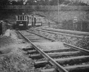
59 was one of Budapest's so-called "mountain routes", built by BKVT on
the Buda hillsides. The other two were today's route 56 to Hűvösvölgy,
and route 58 to Zugliget, closed
in 1977. The difference between these routes were that while the other
two went up to popular excursionists' and picknick locations, the outer
terminus of route 59 was the Farkasrét cemetary, which was opened
in 1894 on the southern hillside of Mártonhegy. The line was inaugurated
on December 4. 1902 between Déli pályaudvar (Budapest South train
station) and the main gate of the cemetary, partially with only one track.
The service was extended to its current terminus in 1913. Interestingly,
the line received the number "59" right when they started to use route
numbers instead of coloured plates in 1910, and it still bears this number,
making it the oldest route number still serving the same route (well, almost:
the line's original inner terminus was Krisztina tér and Déli
pályaudvar for a while)!
 The
rest of the route's history is pretty relaxed: the second track was built
out on the entire length of the line in 1925, and this was also the year
when the inner terminus was moved to the newly built reversing loop at
Déli
pályaudvar. The terminus was relocated again when the Széll Kálmán tér
tram junction was completed (1942).
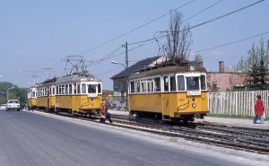
The route - like many others - was threatened by closure in the seventies, but local people and authorities were able to prevent that, so instead of buses they've got a grand renovation. This was also the first line to feature Tatra T5C5 cars in 1980. Back then they were running coupled with both driver's cabs facing forward, or even solo - this was possible because the line had reversing loops on both ends. Since then the biggest change is that the trams are not reversing at Széll Kálmán tér, but go up to Szent János kórház. Oh, and around 2004 the name of the upper terminus was changed from Farkasréti tér to Márton Áron tér.
On All Soul's Day(s) there used to be an insection service called 59A, for which they've built a reversing switch near the main gate of the cemetery, but it's not used anymore. Instead the whole line has a denser headway during that period. Today's route number "59A" refers to early-morning and late-night short-workings, when the line terminates at Széll Kálmán tér instead of the normal lower terminus Szent János kórház.
![]()
Special remark: This route has a continous ascent of 5.3% in 1900 meters length.
Route 59: Szent János kórház - Szilágyi Erzsébet fasor - Széll Kálmán tér - Krisztina körút - Alkotás utca - Nagyenyed utca - Böszörményi út - Apor Vilmos tér - Jagelló út - Németvölgyi út - Érdi út - Farkasrét, Márton Áron tér (5.6 km)
Vehicles: 9 x double-sets of T5C5K (from remise Szépilona)
Route 59A: Széll Kálmán tér - Krisztina körút - Alkotás utca - Nagyenyed utca - Böszörményi út - Apor Vilmos tér - Jagelló út - Németvölgyi út - Érdi út - Farkasrét, Márton Áron tér (4.1 km)
Vehicles: 3 x double-sets of T5C5K (from remise Szépilona)
Special remark: This route has a continous ascent of 5.3% in 1900 meters length.
![]()
On 21. August 2007 the "lower" terminus of this service was moved from Széll Kálmán tér to here. This is the only tram line in Budapest with reversing loops on both ends.
Although the reversing loop is nice, with a small park in the middle, I have always found it hard to make good photos of it. Maybe you will have more luck with it :)
The joint section between Szent János kórház and Déli pályaudvar
The service uses the same path as route 61 between its terminus and Déli pályaudvar.
-> Jump
to route 61 heading for Hűvösvölgy
-> Jump to
Széll Kálmán tér
Between Széll Kálmán tér and Déli pályaudvar they also share ways with route 18. To make this "bottleneck" more permeable, the tracks were laid on reservation - although motorists sometimes block the way of the trams at level crossings.
We usually call this underpass (built in 1937) "the tunnel". It's a good place to take photos...
... and if you're there during rush hours, you can even observe some queuing.
The next section of Krisztina körút is not very spectacular, but the three-track turnout before Déli pályaudvar provides another good photo opportunity.
Until 2000 this was a four-track junction, but after a redesign only three remained. Route 59 and 61 take the straight track to Alkotás utca...
... while route 18 takes the midle one, and turn onto the continuation of Krisztina körút. Note the yellow lamp posts/overhead masts: noone knows why, but they're using this color along route 61!
-> Switch over to route 18 heading south via Krisztina körút
Route 59 and 61 share platforms here, while the stop of route 18 and 56 is located on the other side of the train station. The platforms can only be accessed via an underpass; going through the traffic lanes on the surface is very dangerous! On the picture to the right you can see the turnout of route 59. This is a much simpler one than the previous turnout, there are no extra tracks. In the background you can make out the building of the train station - there's also a siding there leading to the "big railway" tracks, but it's not used anymore.
At the turnout you can make photos with the northern end of the Castle District visible behind the railway station (see above). The short section in Nagyenyed utca is quite steep, and after about 200 meters we arrive to Böszörményi út.
In this narrow and winding street road surface is shared with other vehicles. Unfortunately this has a strong negative effect on the "concrete panels" out of which the trackage is built here.
Buses and cars on the tram tracks: as of 2005, a renovation would be warmly welcome.
On the other hand, despite the worn street surface and the houses with delapidated stuccos, this part of the city has a much more relaxed mood than the previous section.
At Apor VIlmos tér, the line enters private right-of-way again.
You will see lots of sand between the tracks: this is the result of the Tatra trams automatically pouring sand on the rails at the event of wheel slips/skids to enhance adhesion.
From here on the route winds and climbs up to the end - maybe not as spectacularly serpentining as route 15 of Basel, Switzerland, but it's quite long, and has a number of photogenic spots.
It gets more and more green as we climb upwards (except in the winter of course:)...
... until we reach the cemetery. After the main gate the gradient is interrupted for a short section for the reversing switch (left). The section between the switch and the terminus features a nice 90-degree-bend (right), and rails bolten to a concrete layer instead of sleepers.
This ascent is the last one: the tram then reaches a plateau, where the terminus is located.
This is one of the last termini in Budapest with a reversing loop. It has a rather small radius, which the Tatra trams don't tolerate, hence they screech loudly despite their bogie construction and the stationary flange lubricators installed by the rails.
The terminus is used awkwardly: not all trams go round in the loop - some of them leave the terminus via the crossover at the entrance (see graph). There's also a stub reserve track in the middle.
I conclude this page with two "everyday impression" of the reversing loop. I think it's worth to take a ride on this route when you're in Budapest, even if there's not much else to see around here!
![]()
Back to the
top
Back
to the opening page
Back
to the clickable map
Disclaimer: The author cannot
be held responsible for mistakes, misinterpretations, inaccuracies, inactualities,
etc. on/of these pages, nor for the content of other pages linked in.
![]()
Send
a mail to the author
The
author's homepage