The Pesterzsébet "giant loop" and route 52
The large, single-track loop running in the small streets of Pesterzsébet is one of the most anachronistic features of the Budapest tram network. Tram 51 reaches it from north-northwest, tram 52 comes from east-northeast, while tram 3 merely touches the vicinity as it runs along in Határ út:
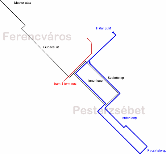
Nowadays route 52 caters the whole loop, which includes both the "inner" and the "outer" loop, while tram 51 turns back to north by doing the inner loop only. Due to the nature of a loop, stretches of this interesting facility are always well-lit by the sun, but the many right angle turns also make tram 52 a feast for tram photographers - not to mention the greatly varying backdrops: you have industrial sites, large communist-style housing areas, small-village blocks, early 20th-century residential areas, with some countryside-ish looking streets in the outer loop. It is suggested to come here on a working day, when the rush-hours sport a 10-minute succession even in the outer loop - in the evening and on weekends, headways are long, so you'll have to wait long for every photo opportunity!
To put it simple, Pesterzsébet was one of the places where industrial labour has settled around the end of the 19th century, just outside of Budapest (Határ út was the city limit until 1951). HÉV (suburban railway) and tram lines were built to transport workers from here to the factories of Budapest (mainly Ferencváros) and Csepel (also part of Budapest since 1951) in the first place. The two main tramway companies of Budapest approached the settlement on different paths: BVVV reached Pesterzsébet (called Erzsébetfalva) in 1905 via Gubacsi út, while BKVT could only penetrate the village via a detour in 1907, utilising its subsidiary company BHÉV (since BVVV had a concession for trams in Pesterzsébet, BKVT could only operate suburban railway (HÉV) services there).
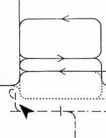
The drawing to the left shows the two BVVV routes launched in 1905 (... - Gubacsi út - Határ út - Jókai Mór utca - Nagysándor József utca - Török Flóris utca - Határ út - Gubacsi út - ...) and 1909 (... - Gubacsi út - Határ út - Baross utca - Nagysándor József utca - Határ út - Gubacsi út - ...). The other drawing hints (with the dashed line) how the BHÉV loop (... - Ónodi utca - Erzsébet utca - Pöltenberg utca - Vörösmarty utca - Hunyadi utca - Kmetty utca - Ónodi utca - ...) penetrated Pesterzsébet without being connected to the BVVV lines. This HÉV line was connected to the (still existing) HÉV service between Közvágóhíd and Dunaharaszti (in 1912, BHÉV also launched another branch line of that main route, to Csepel). Of course this map in fact shows the already extended (via Székelyhíd utca - Török Flóris utca - Előd utca - Vörösmarty utca) HÉV loop from 1914, but the separeteness of the services can be observed very nicely.
If you can still follow me, you might have already realised that today's inner loop is one of the BVVV's routes, while the outer loop uses the former HÉV alignment - but the story is not that simple!
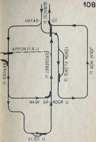
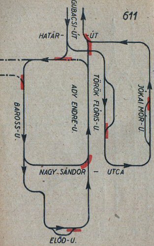
Left: HÉV and tram united
on a map from 1941. Right: the HÉV received a new entrance into the loop
system (map from 1951).
The Pesterzsébet BHÉV line was in fact a disguised tram operation, with tram-like vehicles running under tram voltage - for a while it was even operated by the joint tram company set up after BVVV and BKVT was bought by the city. In 1925 BHÉV regained control of its former line, but in 1933 BSzKRt bought the majority of BHÉV's shares, and from 1938 they even operated a direct service from Pacsirtatelep to Csepel. For reasons unclear for me, the two ex-BVVV tram loops were separated in 1940, resulting in two unconnected lines, with the western one featuring a shortcut via Nagysándor József utca (then called Nagy Sándor utca). The HÉV's stretch inside the ex-BVVV tram loop was abandoned and replaced with a detour from Baross utca via Madách utca, and in 1942 the HÉV's entry into the loop was moved to Határ út.
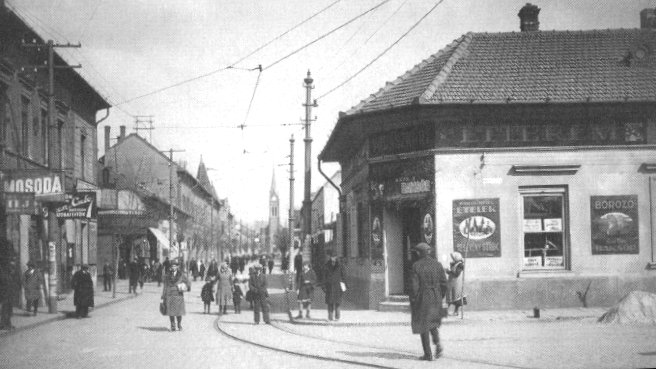
The original HÉV line in
the S-shaped bend Vörösmarty utca - Hunyadi utca - Kossuth Lajos utca
I know this is hard to follow, one can only understand it by having a map at hand to follow the street names. Or maybe not even so: some of those streets are long gone (or were moved from their original alignment when today's housing areas were built)...
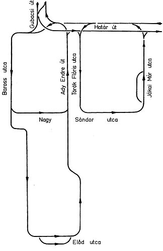
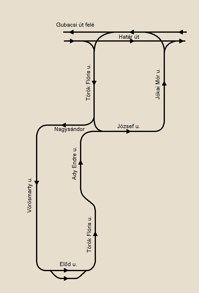
Left: the two (and a half)
loops in 1972. Right: today's situation.
In 1951 today's Boráros tér - Csepel HÉV service was launched, the Pesterzsébet - Csepel line was closed in turn. This turned out to be a bad decision, so it was relaunched in 1958, but this time ending at Határ út without entering the Pesterzsébet loop. In 1959, tram 13 arrived via a newly built section in Határ út between Jókai Mór utca and Nagykőrösi út - this is where now tram 3 runs.
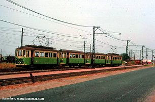
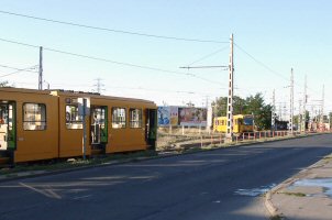
The final section of the
Csepel-Pesterzsébet HÉV was single-track. The track in the foreground
belonged to tram 31 heading for
Baross utca, its remnants are now
used by tram 3 as a reserve track.
In 1974 the stretch in Baross utca and Madách utca was abandoned because pretty much the whole area was torn down to make room for a modern high-rise housing area. Yes, that's right: more inhabitants came, yet the tram was not modernised but removed! A new connection was (re)built in Nagysándor József utca between Ady Endre utca and Török Flóris utca so that the outer loop could still be reached. Sadly, this wasn't the end of the tram withdrawal yet: in 1979 Ady Endre utca was cleared of trams, resulting in today's "one and a half giant loop". The HÉV to Csepel was also closed in 1978. The last missing piece of today's tram 52, the stretch in Határ út between Nagykőrösi út and Kispest, Határ út (M) was built at the end of the 1970s.
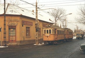
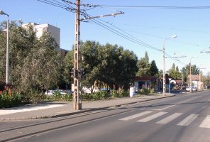
Before and after the housing
programme: small houses giving way to high-rise blocks - only the overhead
posts remained.
The typical tram services of Pesterzsébet were 30, 31 and from time to time 13. Today's tram 52 was launched in 1980, and has nothing to do with the earlier tram 52, which ran in Üllői út, and was dropped in 1977. Tram 31 (Közvágóhíd - Pacsirtatelep) was closed in 1995, tram 30 was renumbered to 21 in 2008 and then to 51 in 2011.
Okay, I think you're mixed-up enough now :) Let's move on to today's tram lines!
Kispest, Határ út (M) - Határ út - Török Flóris utca - Nagysándor József utca - Vörösmarty utca - Pacsirtatelep/Előd utca (intermediate terminus) - Török Flóris utca - Székelyhíd utca - Ady Endre utca - Nagysándor József utca - Jókai Mór utca - Határ út - Kispest, Határ út (M) (13.6 km)
Vehicles: 6 x TW6000 (from remise Száva)
Timetable of route 52 on the BKV website
On this page you might see the old route
number appearing on photos, because I have more pictures of that era, than
of today.![]()
Török Flóris utca, heading for Nagysándor József utca
Today's Pesterzsébet loop services enter the loop by turning into Török Flóris utca from Határ út. This is the border between old day's Pesterzsébet and the housing area that now occupies much of its downtown.
Some highrise modernity on this side of the tracks (left), and old one-story houses in small-village-manner on the other (left).
The track runs on reservation for a few hundred meters and is therefore nicely photographable, especially in the morning (left). After we cross Topánka utca, the modern-day main street of Pesterzsébet, trams return to the side of the street surface.
Szent Erzsébet tér and Kossuth Lajos utca (perpendicular to the tram's way) was preserved somehow in the middle of this modern housing area. With the catholic church (not seen on these photos), this once used to be the center of the settlement. From here it goes downwards (right).
After running along more high-rise blocks, we reach Nagysándor József utca, where tram 51 turns left (right side for us on the photo above to the left), taking the shorter way out of Pesterzsébet. Tram 52 turns the other way, and heads for the outer loop. The stop before the turnout is tram 51's terminus, it waits there a few minutes - unless there's a tram 52 right behind.
-> Over to route 51 taking the shorter way out of the Pesterzsébet loop
Nagysándor József utca, heading for Vörösmarty utca
For just one block, the two directions of tram 52 run (almost) side-by-side. To the left: tram 52 heading for Határ út, to the right: only one track leading towards Pacsirtatelep.
One side of the road is bordered by small houses (as seen to the left), the other by a large high-rise housing area (as seen in the background to the right, behind the noce old heritage tram). It's hard to understand why the tram then turns to even more rural vicinities instead of penetrating the modern housing area!
At Vörösmarty utca we reach this nice tight bend:
To tell the truth, I don't really know when exactly the sun shines from the right angle to get a shadow-less shot of this curve. Probably sometimes fore-noon... The next few hundred meters are more easily photographable, and also quite photogenic.
Here's a short video of a UV set in the tight bend.
| Lost
rails: Madách utca
Madách utca was where the trams doing the "western small loop" reached the "outer loop" which was originally built for the HÉV. Although this line was abandoned in 1974, there were still remnants of it in the pavement until a few years ago (some "lost rails" might still be in situ on the other end of the street). |
I would say this street-running stretch is the most photogenic one, unless of course a car gets into the picture :)
To the left: a winter night in Vörösmarty utca. To the right: the track leaves the street surface before reaching the small market at Vörösmarty tér. Although the term "market" suggests crowds of people, this is a rather forlorn place for most of the times.
After another right-angle turn to the left, we reach the terminus.
Originally this was where the drivers of tram 52 (and 30) have had their pauses ...
... and you'll see from the size of the whole facility, that this used to be a more busy place. Now it's quite desolate, although still a good spot to take photos. To the right: the last tram 30 running to Pacsirtatelep, before the line was shortened to its current length.
Török Flóris utca, heading for Székelyhíd utca
After we leave the terminus, the tram makes another right-angle turn, and reaches Török Flóris utca - again, but this time heading for the opposite direction.
This part is a bit less narrow, but the car traffic can be strong, so it's harder to make decent photos than in Vörösmarty utca.
After a while, the tram makes an S-shaped detour via Székelyhíd utca. This section really reminds me of the Silesian suburban trams around Katowice.
The next right angle turn (left) takes us into Ady Endre utca (right), and after a few hundred meters, we're in for another right angle turn, into Nagysándor József utca (again).
Nagysándor József utca, heading for Jókai Mór utca
After a while running next to the outbound tracks of tram 52, we reach the end of the outer loop, and enter the inner one.
To the left: tram 30 (now called 51) turning from Török Flóris utca into Nagysándor József utca. To the right: tram 52 heading for Határ út in the afternoon, when this street is best photographable.
This stretch is not really long, soon the track takes another right angle turn into...
Jókai Mór utca is a mixture of small-village rows and old-style housing blocks.
I really like how the tram runs close to the houses on the side of the street, although I'm sure some of the local folks feel different about this: some of these houses were built very cheaply, and due to the poor condition of the track (lack of proper vibration damping), these houses suffered damages over the decades.
At the end of the dead-straight street we have the turnout, where tram 51 and 52 part ways: the first turns left as it heads back to Gubacsi út, the latter turns the other way.
-> Over to route 3/51 in Határ út
The standalone section of route 52 in Határ utca
Until reaching the Nagykőrösi út triangle junction, tram 52 shares the tracks with tram 3.
From there it runs through a section tram drivers call "petit forest" (kiserdő). It's a well-separated stretch, where the UVs used to test their top speed. Nowadays there's a speed limit, because the copper cables of the current feed were stolen (probably multiple times), dangerously overloading the overhead wire. Also, between the trees you can see tents and makeshift booths of homeless people.
And as we leave the trees behind, we reach the Határ út terminus, where we join the tracks of route 42.
->
Over to route 42
->
Over to route 50
![]()
Back to the
top
Back
to the opening page
Back
to the clickable map
Disclaimer: The author cannot
be held responsible for mistakes, misinterpretations, inaccuracies, inactualities,
etc. on/of these pages, nor for the content of other pages linked in.
Archive photos: Heinz Heider,
tramway.com and from the collections of Dr. Zoltán Ádám Németh and Zsolt
Levente Nagy
Track layout drawings: BSzKRt/FVV/BKV
(from the collection of Dr. Zoltán Ádám Németh), Fejes Balázs
![]()
Send
a mail to the author
The
author's homepage