Tram-hiker's
guide to Budapest
Latest update: 5. January,
2016
![]()
Route
3, 62/62A and 69 - page 1
Tram-hiker's
guide to Budapest
Latest update: 5. January,
2016
![]()
Route
3, 62/62A and 69 - page 1
Route 3 is basically a fourth tram ring around Pest (the first being the now truncated Small Boulevard (route 47 and 49), the second the Grand Boulevard, and the third route 1). It already existed in segments, but was only created in 2001 as the main operation area of the TW6000 trams just bought from Hannover. Before that point of time, the same route was done in two pieces, by tram lines 13 and 63. Unfortunately the route itself was not upgraded to the level which the ex-Hannover vehicles were "used to" in their home town. The consequence is that this line is quite slow at some stretches, mostly due to the lack of priority to vehicular traffic. On the other hand there are many interesting objects along it: crossings, a remise, some more crossings, at one point with an industrial siding. Most of the line was renovated in 2014 with brand new tracks on some stretches, new platforms in the stops, and since September 2015 this is the second tram service in Budapest (after lines 4/6) using CAF low-floor vehicles among the ex-Hannover trams.
Trivia: The route number 3 is a "recycled" one: it used to be the classic main tram service on the Váci út tram corridor, made obsolete by the M3 metro line in the eighties.
Route 62 has a bit longer history: it was launched as a connection between the quarter Pestújhely, reached by the now non-existing tram route 67, and the to-be center of quarter Zugló, Örs vezér tere, then served by the now-non-existing routes 64 and 68. Its operation started in 1964, and it remained on the same path until the launch of route 3, when it was extended to Mázsa tér in Kőbánya. Since Fall 2008 the route runs to Népszínház utca/Blaha Lujza tér during peak hours (over the existing tracks of route 28), and to Mázsa tér in off-peak hours as route "62A".
Route 69 is a relatively new tram service. Until 1970 this number was assigned to a service converted out of a HÉV line between Rákosszentmihály and Rákospalota (the "lost" tram line 65 was a fragment of this route). This service has only had one common location with today's tram 69: Mézeskalács tér (since Fall 2008 again called Rákospalota, MÁV-telep), but the old route ran at right angles to the new one. The new incarnation was built to connect the large high-rise housing area in Újpalota to the newly extended Kisföldalatti ("Shallow subway" or metro line M1). It's was an extension of tram 67 with a short connection between Erzsébet királyné útja and Kacsóh Pongrác út via Mexikói út, and a longer stretch from Rákospalota, MÁV-telep to Újpalota, Erdőkerülő utca.
From this point on, the main subject of the page will be route 3. In accord with this, the in-line Google maps will show this service in three sections, although the other two routes are also mentioned in the text.
As I mentioned above, a part of today's route 3 and 62 (in Erzsébet királyné útja) was based on route 67, which itself was a branch-line of the now-closed Thököly út line, which later spawned another stretch of line 3 - between Bosnyák tér and Örs vezér tere. The line that was later known as tram 67 branched off in 1902 via Mexikói út and Erzsébet királyné útja, to the crossing of Nagy Lajos király útja. One year later it reached Öv utca.
The next stretch came in 1933 in Nagy Lajos király útja, between Bosnyák tér and Egressy tér. In 1947, the Erzsébet királyné utca line was extended to Rákospalota, MÁV-telep. The "missing" parts of route 62 in Nagy Lajos király útja were built in 1960 ( between Egressy tér and Örs vezér tere) and 1964 (Erzsébet királyné útja - Bosnyák tér). The terminus of route 62 was a stub one on the northern side of Örs vezér tere, and remained that way until 2001. The other side of Örs vezér tere, on the other side of the busy road Kerepesi út and the HÉV line to Gödöllő, received its first tramline in 1963 (tram 13). The newest stretch on this end of the line was the short one in Mexikói út: it was built in 1973, when today's route 69 was also launched.
 The
history of the next part is also a complicated one: horse trams of BKVT
have been running to from Baross tér to Kőbánya since 1868,
and this line ended in today's Kőrösi
Csoma Sándor út. This branch was electrified in 1897, and extended
to today's
Éles sarok (where BVVV's
line to Új Köztemető - today's route 37
- ran) in 1928. This gives us the stretch between Éles sarok. and
Mázsa
tér.
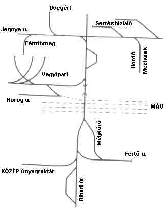
The predecessor of the stretch between Mázsa tér and the crossing of Üllői út was a steam-hauled industrial (freight) railway serving the factories in the vicinity. The company started in 1888, but was closed in 1944. After WW2, the network was operated by the municipal transit company BSzKRt, and then FVV, but without electrification, still using steam locos. It was during that time, that a bus line 13 penetrated the area between Liget tér and Üllői út. The demand for public transportation here turned out to be so high that a part of the freight railway was converted into a tramway, with the new line receiving the number 13.
On the map to the right (drawn by Zoltán Ádám Németh) you can see that the single-track line (vertically on the drawing) has had two passing loops, and lots of sidings to the factories around.
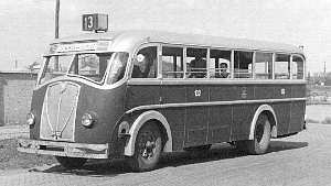
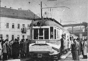
A bus of route 13 around
1950 (left), and the very first tram 13 on October 16. 1955 at Mázsa
tér (right). Photos: villamosok.hu, the collection of Zoltán Ádám Németh
Many of these sidings remained in use until the 1980s, and their last remnants disappeared only around 2000. The stretch received a second track in 1960, but a short single-track section (with a railway crossing in level) remained until 2014 as the last of its kind in Budapest.
Trivia: The route number 13 was first used after 1948. Until that, this number was omitted whenever possible, but the communist regime wanted to demonstrate its disdain concerning superstition.
The section between Üllői út and Gubacsi út
Now we arrived to the crossing of Üllői út. The section from here to Határ út/Nagykőrösi út was built partly out of a branch of the industrial network of Kőbánya, and partly out of another freight railway, used to transport litter to the waste dumps outside the city. The company BSzKRt converted these private operations to tram route 51. The last stretch of today's tram 3, between Nagykőrösi út and Gubacsi út (more precisely: between Nagykőrösi út and the "giant loop" of Pesterzsébet) was built in 1959.
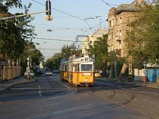
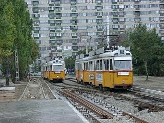
The short-lived route 63
in early autumn 2001
What we had by the end of the 20th century were two tram lines (62: Mézeskalács tér - Örs vezér tere and 13: Örs vezér tere - Gubacsi út) ending vis-a-vis on Örs vezér tere, without any direct connection. Then the plan of a new almost-circular route came up, with Mexikói út/Kacsóh Pongrác út as the northern terminus. This meant that a new connection has had to be built in the crossing of Nagy Lajos király útja and Erzsébet királyné útja, where route 62 has only had an outbound connection. This was built quickly, making this turnout a triangle junction. The connection through Örs vezér tere was yet to be built, meanwhile a new tram service was started between Mexikói út/Kacsóh Pongrác út and Örs vezér tere, known as route 63 (another "recycled" route number). This service hardly lasted a year: on October 3. 2001 route 13 and 63 was united into route 3, and route 62 was extended to a newly-built terminus near Mázsa tér. For a while the TW6000s of route 3 were running mixed with TW6000s and UVs of route 62, making the junction Éles sarok, where route 3 and 62 meets routes 28 and 37 a cavalcade of different tram types.
Now, I know all these names and dates are tiring, but I think this explains why this line is so varied. Don't worry, this was the hardest-to-follow part of this page ;)
There are plans for extending the service on both ends. On one end it should receive a new stretch in Nagy Lajos király útja, a flyover over the railway line to Esztergom and Vác, and another new stretch in Szegedi utca 'til reaching route 14 at Béke tér. On the other end the route would reach Budafok on newly built bridges over the Danube, crossing Csepel island (see map below). I must say I doubt that this will ever happen, as not even the first stage of the extension (between Gubacsi út and the HÉV line to Ráckeve) was built until now, despite it being only a few hundred meters!
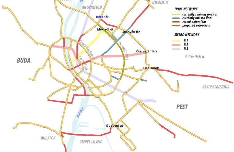
Map (C) Tibor Szilágyi,
modified by yours truly
Remark: the map above shows proposed new lines and extensions as they were thought about around 2004. Since then the metro line M4 got highest priority, and is just about the only public transit development being built. I included this map only to show what route 3 should be, or should have been...
Route 3:
Mexikói út (Kacsóh Pongrác út)
- Mexikói út - Erzsébet királyné útja - Nagy Lajos király útja - Örs vezér
tere - Fehér út - Élessarok - Kőrösi Csoma Sándor út - Liget tér - Kőbányai
út - Mázsa tér - Bihari utca - Ecseri út - Epreserdő utca - Napfény utca
- Határ út - Pesterzsébet, Gubacsi út (13.4 km)
Depot: Száva, Zugló
Route 62:
Rákospalota, MÁV-telep - Kolozsvár
utca - Erzsébet királyné útja - Nagy Lajos király útja - Örs vezér tere
- Fehér út - Élessarok - Kőrösi Csoma Sándor út - Liget tér - Kőbányai
út - Orczy tér - Fiumei út - Népszínház utca - Blaha Lujza tér (14.2
km)
Depot: Száva, Zugló
Route 62A:
Rákospalota, MÁV-telep - Kolozsvár
utca - Erzsébet királyné útja - Nagy Lajos király útja - Örs vezér tere
- Fehér út - Élessarok - Kőrösi Csoma Sándor út - Liget tér - Kőbánya
alsó vasútállomás/Mázsa tér (9.7 km)
Depot: Száva
Route 69:
Mexikói út (Kacsóh Pongrác út)
- Mexikói út - Erzsébet királyné útja - Kolozsvár utca - Besenyő park -
Bánkút utca - Páskomliget utca - Nyírpalota út - Zsókavár utca - Újpalota,
Erdőkerülő utca (6.5 km)
Depot: Zugló
Next page: from Mexikói út to Gubacsi út
Disclaimer: The author cannot be held responsible for mistakes, misinterpretations, inaccuracies, inactualities, etc. on/of these pages, nor for the content of other pages linked in.